
Passive Seismic Tomography
Active seismic tomography is routinely employed by oil and gas exploration firms to gain an understanding of subsurface geology. This involves measuring how acoustic waves travel through the Earth’s crust.
Similar to the way light refracts as it passes through water, acoustic waves alter their speed and direction as they cross boundaries between different materials. A network of sensors on the surface measures these vibrations, and complex software analyzes the data to create a map of the subsurface geology. This method is termed ‘active’ because the acoustic waves are produced mechanically, either with hydraulic rams on a ‘thumper truck’ that sends vibrations through the ground or, for larger areas, via controlled surface explosives. These acoustic waves are generated on a grid pattern across the area to be surveyed, sometimes as close as 25 m apart. This surveying method is resource-intensive and constitutes a considerably expensive component of oil and gas exploration.
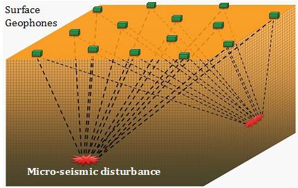
In our exploration of white hydrogen, we utilize passive seismic tomography to survey the Namibian concession. Although more time-consuming than the active seismic technique, the data collected is of comparable quality, at a projected cost of $200 per km², compared to $20,000 per km² typical of active seismic tomography. Instead of generating acoustic waves on the surface and measuring the response, passive seismic tomography relies on natural micro-seismic activity to understand the subsurface geology. In this method, a grid array of geophones is placed on the surface to monitor naturally occurring micro-seismic disturbances. When micro-seismic activity occurs, each surface geophone records the disturbance. By comparing and analyzing the disturbances recorded by each of the geophones for the same micro-seismic event, we can make interpretations of the subsurface geology. The concept is illustrated below.
Contact
- 20 Wenlock Road London N1 7GU
- +44 203 968 1801
- info@h2earthdynamics.co.uk