Gravimetry Surveying
Gravimetry surveying was one of the first geophysical methods to be used in hydrocarbon exploration. As the name suggest, this method uses accurate measurements of the Earth’s gravitational field to locate horizontal and vertical variations in the density of subsurface rocks. Much like aeromagnetic surveying, an aircraft fitted with a gravimeter flies in a grid like pattern over the area of interest, measuring and recording the earth’s gravitational pull.
Because different rock types and mass quantities differ in their gravitational pull, the gravitational data can also be processed to create a visualisation of the geolocal composition of the upper crust.
We have partnered up with Rolf Heyen, head of the institute of flight guidance at the University of Braunsweig in Germany, to conduct gravimetry in tandem with aeromagnetic surveys from the modified gyrocopter. We believes that analysis of data from both surveying techniques is necessary to create a highly accurate visualisation of the subterranean geology.

Radiometric Surveying
Uranium and potassium occur naturally in the Earth’s crust and emit highly energetic gamma rays as they slowly decay. These elements were randomly distributed throughout the Earth as it cooled during formation and contribute to the background radiation that occurs around us. Both elements are relatively immobile while they remain undisturbed in rock, however in contact with hydrocarbons an oxidization process occurs.
Hydrocarbons migrating from a trap that come into contact with these elements make them water soluble, allowing them to migrate towards the surface much more easily. Once at the surface, potassium tends to be carried further afield by wind and rain, while contact with organic material returns the uranium ion to its insoluble, and less mobile state.
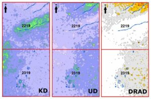
ANE has flown radiometric surveys over the concession in Namibia and created a 2D map of radiation levels from uranium and potassium. A number of locations show potassium levels dropping off where uranium levels increase – characteristic of the effects hydrocarbons have on the presence of these elements.
The above image shows potassium (KD) and Uranium (UD) deviation across the concession. DRAD shows the mean of the two and highlights the anomalies where low potassium and higher uranium levels occur. These anomalies have been found to correlate with those identified by satellite imaging and examination of surface geology.
Aeromagnetic Surveying
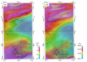
Aeromagnetic surveys are conducted to detect variations in the earth’s magnetic field. In this surveying technique, an aircraft equipped with a magnetometer flies in a grid-like pattern over an area of interest. As the aircraft flies, the magnetometer measures and records the intensity of the magnetic field at the sensor.
The intensity of the magnetic field is a combination of the field generated in the earth, as well as tiny variations due to the temporal effects of the constantly varying solar wind, and the magnetic field of the aircraft. By subtracting the effects of the solar wind and aircraft, an aeromagnetic map can be created which details the abundance of magnetic minerals in the upper levels of the earth’s crust.
Because different rock types, and mass quantities differ in magnetic properties, the aeromagnetic data can be processed to create a visualisation of the geological composition of the upper crust. This technique is particularly useful in identifying the depth of base rock, the depth of sedimentary layers, and the location of fault lines within the upper levels of the earth’s crust.